Main study areas in brief
Apulian Tavoliere, Southern Italy
A key agricultural region characterized by:
- Mediterranean climate
- Intensive irrigated agriculture (tomato production)
- Water scarcity challenges
- Historical SAR observation campaigns (SARSIMHT-NG)
- Historical ESA-JAXA ALOS-2/Sentinel-1 collaborative campaigns
- Long-term in situ soil moisture networks
TERENO Rur Catchment, Western Germany
An environmental observatory featuring:
- Temperate climate
- Mixed agricultural and forested landscapes
- Comprehensive hydrological monitoring infrastructure
- Soil moisture sensor networks
- Historical ESA-JAXA ALOS-2/Sentinel-1 collaborative campaigns (SARSENSE)
- Well-studied validation site for low-resolution satellite soil moisture products (SMOS, SMAP)
Castilla y León region, Spain
A major agricultural region in north-central Spain featuring:
- Semi-arid to temperate climate
- Duero River basin with 85% arable land
- Dominant winter cereals (wheat, barley) and diversified cropping systems
- Riaza irrigation district supporting intensive summer crops
- Two comprehensive monitoring networks: InfoRiego and REMEDHUS
- Well-studied validation site for low-resolution satellite soil moisture products (SMOS, SMAP)
What follow are more detailed descriptions of such hot-spots for the research and validation activities in the project.
Apulian Tavoliere
The Apulian Tavoliere, also known as the Capitanata, is a vast plain of approximately 4,000 km² located in the northern part of the Apulia Region (southeastern Italy), within the province of Foggia. It is bordered by the western Apennine mountain range to the west and the Gargano promontory to the east. Geologically, the area consists mainly of continental and fluvial sediments, along with terraced marine deposits from the Pliocene and Pleistocene epochs.
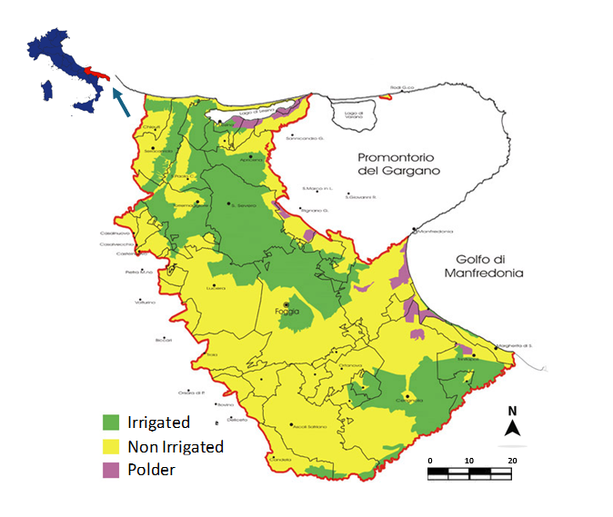
The region is characterized by medium-sized farms (up to 20 hectares), highly productive clayey soils, and intensive irrigated agriculture. The dominant cereal crop is winter durum wheat (Triticum durum Desf.), typically grown in rotation with irrigated horticultural crops. Among these, processing tomato (Lycopersicon esculentum Mill.) is particularly prominent. Common crop rotations include two-year cycles (tomato–wheat) and three-year cycles (tomato–wheat–wheat). Over the past 5–8 years, autumn intercrops such as fennel and broccoli have become increasingly widespread, contributing to more dynamic and intensive cropping systems.
Capitanata spans two climate zones—temperate (Cfa) and semi-arid steppe
(Bsk)—according to the Köppen-Geiger 2017 classification. Winters can be cold,
with temperatures occasionally dropping below 0 °C, while summers are hot, often
exceeding 40 °C. Annual precipitation ranges from 400 to 800 mm (average 650
mm), concentrated mainly in the winter months, with October and November being
the wettest. The dry season typically extends from May to September. The soils
are generally deep and clay-rich, exhibiting vertical cracking during dry summer
conditions. A large portion of the area is irrigated through the Consorzio per
la Bonifica della Capitanata, which supplies water for spring–summer crops. In
other areas, irrigation is supported by private wells, although groundwater is
located at considerable depths (200–300 m).
The Apulian Tavoliere has been a focal point for Earth Observation (EO) research
since the early 2000s. A comprehensive dataset of SAR and in situ measurements
has been collected through various national and international campaigns,
including MIPAF-AQUATER, ESA-GMES, SEOM-Exploit-S-1, SARSIMHT-NG,
H2020-SENSAGRI, ASI-COSMOLAND, PRISMA, SARAGRI, and THETIS.
The site also serves as the designated Italian site for the JECAM initiative. In February 2014, CNR-IREA installed a hydrologic monitoring network in the Cervaro basin at the Segezia experimental farm (400 ha, managed by CREA) (Balenzano et al., 2014). The network consists of 11 stations spaced approximately 500 meters apart, each equipped with Decagon EM50 data loggers and 5TM and 10HS sensors to measure soil moisture and temperature at depths of 2.5, 10, 20, and 40 cm. The 5TM sensors also record soil temperature. An agro-meteorological station complements the network, measuring solar radiation, air temperature and humidity, wind speed and direction, precipitation, and surface soil temperature (Campbell 107 sensor at 2.5 cm depth). In summer 2017, the network was expanded with 10 additional stations at the Manfredini farm (200 ha), also managed by CREA and located in the Candelaro basin. These stations include Decagon 5TM and 10HS sensors, as well as a DeltaT sensor with a rain gauge. Since April 2014, monthly field campaigns have been conducted to calibrate the Decagon sensors in situ, using gravimetric soil moisture measurements to develop site-specific calibration curves. In this respect, the Apulian Tavoliere is a reference site for the validation of soil moisture products derived from SAR systems, including Sentinel-1, ALOS, SAOCOM, NISAR, and the forthcoming ROSE-L mission.
RUR catchment
The Rur catchment, part of the TERENO observatory, spans approximately 100 × 40 km and includes diverse ecosystems such as intensive agricultural fields, managed forests, natural grasslands, and wetlands (Bogena et al., 2018). Covering 2,354 km², the catchment lies mainly in western Germany, with small portions extending into Belgium (6.7%) and the Netherlands (4.6%). It serves as a key site for soil moisture validation for satellite missions like SMOS, SMAP, and ALOS-2, with airborne L-band microwave measurements conducted since 2010. The Selhausen agricultural research station (50.865°N, 6.447°E) represents a heterogeneous rural landscape in the lower Rhine valley. It consists of 52 fields over a 1 × 1 km area, with main crops including sugar beet, winter wheat, barley, maize, and rapeseed. The region has a temperate maritime climate, with an average annual temperature of 10.2°C and precipitation of 714 mm. Soils are classified as Cambisols with silty loam texture.
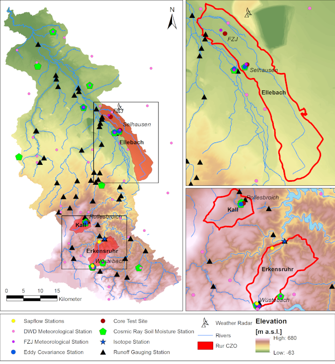
Since 2011, one of the largest fields has hosted an eddy covariance (EC) station supporting the ICOS programme. It records fluxes, meteorological parameters, crop phenology, and farming activities. Groundwater parameters are monitored continuously using a multi-probe system. Since 2015, four automated chambers (Li-8100) measure soil CO₂ emissions, and a SoilNet wireless sensor network tracks soil moisture, temperature, and heat flux at six depths (−0.01 to −1 m) in near real-time.
From 2015 to 2018, Selhausen hosted campaigns comparing methods to partition evapotranspiration into evaporation and transpiration, using isotopes, microlysimeters, and profile measurements. In 2010, 18 lysimeters were installed to precisely monitor water balance components. Two rhizotron facilities allow root growth observation and soil moisture monitoring using ground-penetrating radar (GPR) in both vertical and lateral directions. Electromagnetic induction (EMI) and GPR are used to noninvasively assess subsurface structure and hydraulic properties. At Selhausen, large-scale EMI surveys were conducted using multi-configuration systems mounted on GPS-equipped vehicles. These systems provide apparent electrical conductivity (ECa) at various depths. The area’s river terrace landscape influences crop performance, especially during dry periods. Satellite-derived leaf area index (RapidEye) data revealed patterns linked to paleochannel structures, which correlated with deep ECa measurements, indicating subsoil influence on crop resilience.
Further analysis showed strong correlations between crop development and ECa during dry conditions. EMI data were inverted to create quasi-3D subsurface conductivity models. A subsequent EMI survey across 51 fields, combined with sparse soil sampling and remote sensing classification, produced a high-resolution soil map identifying 18 soil types. This map aligns well with satellite observations of crop development, enhancing understanding of soil–crop interactions.
Castilla y León
A third important site for the project is the entire Spanish region of Castilla y León. The main river basin in the region is formed by the Duero River. The central area of the basin is characterized by 85% arable land. The main winter crops are non-irrigated cereals, especially wheat and barley. Rapeseed and sunflower are increasingly cultivated to promote diversification. Vineyards are the most important permanent crop. The region includes an irrigation district, Riaza (bottom panel), covering 5,232 hectares along a 52 km canal running parallel to the Duero River. Maize is the main irrigated crop, followed by alfalfa, sugar beet, potatoes, and wheat. Two major measurement station networks operate in the region: InfoRiego (red points) and REMEDHUS (blue points).
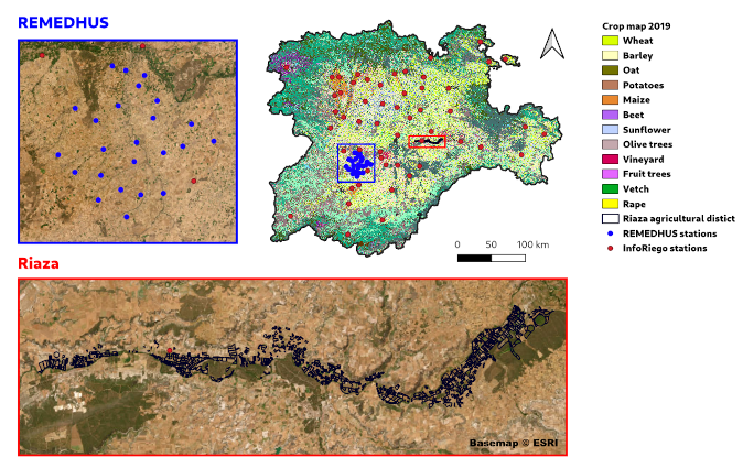
InfoRiego is an irrigation support service (www.inforiego.org) provided by ITACyL, a foreign project supporter, based on the FAO56 methodology. It relies on a network of agro-meteorological stations well distributed across Castilla y León, covering an area of about 220 km × 220 km in the central Castilian plateau at an average altitude of 750–800 m above sea level. According to the Köppen-Geiger 2017 classification, the region spans three climate zones: temperate with humid summers (Cfb), temperate with dry summers (Csb), and semi-arid steppe (Bsk). Average annual precipitation is 390 mm, and the average temperature is 12.5 °C. Soils are mainly sandy loam, clay loam, sandy clay loam, and loam. The stations measure surface soil moisture (0–0.05 m), global solar radiation, air temperature and humidity, wind direction and speed, and precipitation. Soil moisture sensors used are Stevens Hydra Probes.
The REMEDHUS network, managed by the University of Salamanca, is located in the flat (slope <10%) and semi-arid central area of the Duero basin. The soil texture is predominantly sandy (average sand content 70%). The network covers an area of 35 km × 35 km and consists of 20 stations. Soil moisture sensors are Stevens Hydra Probes. Data are freely distributed by the International Soil Moisture Network (Dorigo et al., 2011). The Fontesauco weather station provides precipitation data. REMEDHUS is a well-studied site, used for calibration and validation of low-resolution soil moisture products from satellite missions such as ESA’s SMOS and NASA’s SMAP (e.g., Sanchez et al., 2012).
Other study areas
Po Valley
The site of Jolanda di Savoia is located in an area of the Po Delta, more precisely in the agricultural production areas owned by the company “Bonifiche Ferraresi S.p.A.” The Jolanda di Savoia estate, in the province of Ferrara, is among the largest contiguous agricultural property in Italy, covering about 3,800 hectares.
It hosts a wide variety of crops, with the most extensive being durum/soft wheat and barley (winter crops), and rice, soybeans, maize, and alfalfa (summer crops). The estate is of significant interest for calibrating and validating remote sensing-based methods for estimating crop and soil parameters. Jolanda di Savoia is located on reclaimed marshlands with high variability in soil chemical-physical properties (e.g., texture, cation exchange capacity, organic matter content), which is particularly relevant for soil moisture estimation applications.
Additionally, the large field sizes make them suitable for satellite monitoring using decametric-resolution data and for analyzing intra- and inter-field variability under homogeneous crop conditions (same variety and management). Finally, they benefit from a rich digital geospatial dataset (e.g., soil maps, field polygons, crop rotations) covering recent growing seasons.